Project Summary
The North Nantasket Beach Management Plan was enhanced to:
- Protect and preserve natural resources;
- Identify strategies to repair and protect the dunes to improve their ability to provide storm damage protection to private development and public infrastructure, while maintaining public access to the beach; and
- Create a sense of stewardship in the general public and private landowners.
The beach management plan was originally developed by the Town in 1993. It was significantly updated by the Town in 2007 and 2012 Those involved in the plan development and implementation include the Hull Beach Management Committee, Conservation Commission, Town Manager, Department of Public Works, and Town Counsel. The Massachusetts Department of Environmental Protection and the Massachusetts Office of Coastal Zone Management provided technical support and review of the plan. An environmental consultant (coastal geologist) was hired to assist the Town as part of the 2007 update .
North Nantasket Beach Background
The town of Hull is located just south of Boston in Massachusetts. It has a small landmass of two and one-half square miles and twenty-seven miles of coastline. Although it is a small town, it is one of the most densely populated towns in the Commonwealth. Along the twenty-seven miles of coastline is North Nantasket Beach.
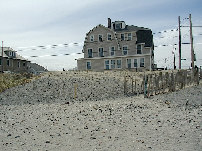
The North Nantasket Beach Management Plan addresses the northern 2 miles of a 3.5 mile barrier beach. There is a narrow, fairly continuous, vegetated primary dune landward of the recreational beach that provides protection to roads, dense development and infrastructure directly behind the dune. The entire area covered by the plan is within the 100 year floodplain, as mapped by the Federal Emergency Management Agency (FEMA). Hull has the third highest number of repetitive loss claims under the National Flood Insurance Program in the state. Over one third of Hull’s flood claims are properties protected by the North Nantasket beach and dune system. The continuity of the frontal dune and protection of its vegetative cover have been identified as essential for storm damage protection and flood control to the development and infrastructure landward of it.
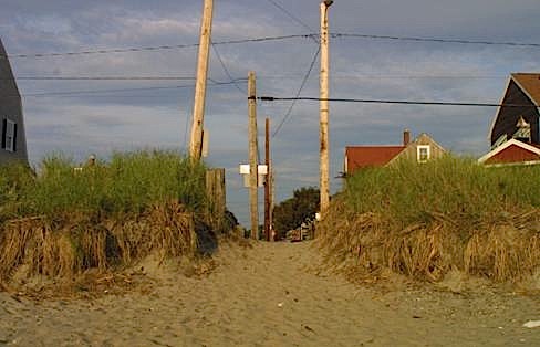
North Nantasket Beach is composed several natural resources protected under the State Wetlands Protection Act Regulations, including beaches, dunes, land containing shellfish, and land subject to coastal storm flowage (100 year floodplain). The beach is also heavily used for recreation, so controlled and managed access points must be maintained from the developed area over the dune to the beach.
The plan recognizes that sea level rise and the increasing frequency and intensity of coastal storms are among the projected impacts of a warming global climate. Sea level is currently rising at nearly a foot per century. While future rates of sea level rise are uncertain, projections are in the range of 2 to 4 feet, or higher, by the end of the century. The dunes serve as critical protection against flooding and storm damage during northeasters. The impacts of climate change will make it more challenging to maintain and protect the dune system – and all the more critical that it is done order to protect lives, property, and public infrastructure.
Project Implementation
In implementing the beach management plan, Hull has focused on both long-term and short-term management actions for the beach and dune system. The plan establishes practices for balancing the competing interests of providing safe access to the beach, increasing the ability of the dunes to provide storm damage protection to landward areas, and maintaining a clean, safe recreational beach. The plan includes protocols for access path maintenance and enhancement, trash and seaweed removal, vehicular access to the beach, and other recreational uses that balance the need for natural resource protection, protection of public health and safety, and recreational use of the beach. With regard to storm damage protection, the management plan focuses on protecting the existing dunes and restoring sections of it where access paths to the beach have resulted in gaps in the storm damage protection and flood control functions provided by the dune.
In 2006, the Town filled eighteen unpermitted cuts through the primary dune with compatible sand and planted beach grass to stabilize the restored sections of the dune. The Town also improved the designated public access paths from the residential area over the dune to the beach. The paths were reconstructed to four feet width and a relatively gentle slope was established to improve accessibility, they were angled away from predominant direction of winds and waves (northeast), and sand fencing was installed along the walkways to contain pedestrian traffic.
In 2006, the Town purchased beach grass to plant and stabilize unvegetated portions of the dune along the entire length of North Nantasket Beach. This supports an existing volunteer effort to plant beach grass every spring to help stabilize the dune. The volunteers typically plant about 15,000 plants per year.
The Plan calls for the Beach Management Committee and the Conservation Commission to review all beach and dune maintenance procedures and invite the public to participate in the review of the procedures.
Project Outcomes and Conclusions
In compliance with the management plan, the Town has made significant progress in repairing and maintaining the primary dune to create a better barrier to storms. They are now focusing on a variety of pro-active planning measures to address sea level rise and the increasing frequency of coastal storms. As part of this work, the Town has identified maintenance and improvement of the dune as critical pieces of their climate adaptation strategy.